![]()
Background
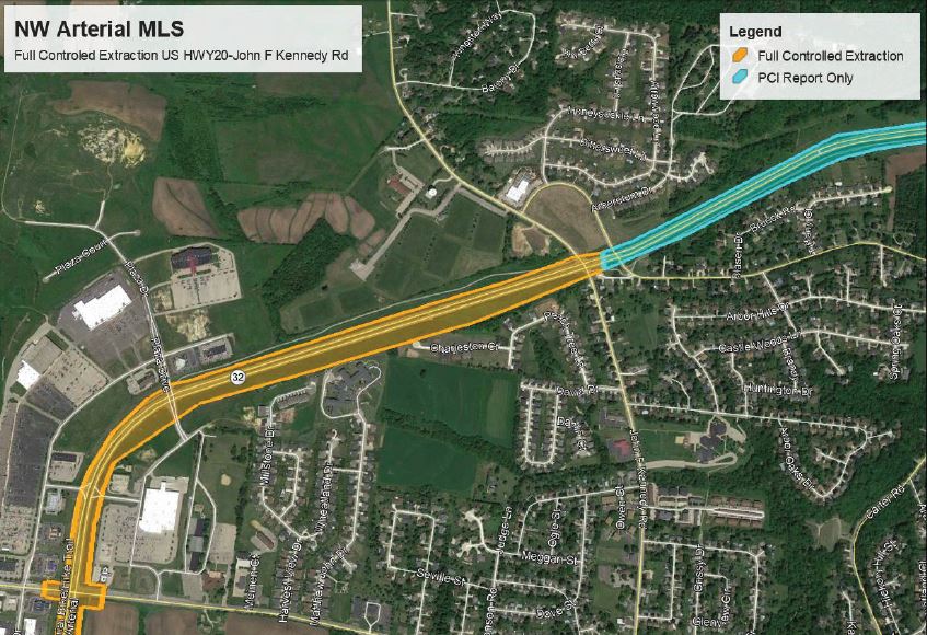
The City of Dubuque hired Foth to assist with pavement reconstruction and rehabilitation of the 5-mile long, major 4-lane urban arterial. Recognizing that this particular section carries more than 30,000 vehicles per day help drive and support the aggressive project schedule.
Approach
In order to safely and efficiently gather the necessary data, our team deployed our in-house Riegl VMX-2HA Mobile LiDAR Scanner (MLS). Project responsibilities and services included the following:
- Project control and documentation.
- Mobile LiDAR Control and documentation.
- MLS data acquisition involving making multiple passes along each corridor in each direction at posted speeds.
- Pavement Condition Index (PCI) on NW Arterial from US Highway 20 to State Highway 3. This information was provided to the City within our Cloud Service “TopoShare” and provided as a unique, protected link.
- Extraction/Topography: All visible surface land improvements within 40 feet of the centerline, including storm and sanitary sewer structures, signal lights, visible utilities, signs, roads, driveways, alleys, sidewalks, trails, curbs, pedestrian ramps, large vegetation, landscaping edges, retaining walls, bodies of water, fences, and buildings were extracted.
Results
The City was provided the following deliverables in order to establish a quality foundation for a successful project:
- 3D Planimetric file in AutoCAD Civil 3D format.
- 3D contour file in AutoCAD Civil 3D format.
- 3D triangular irregular network file of the topographic survey area in AutoCAD Civil 3D format.
- Point cloud file of the project limits.
- 360-Degree video within the project limits.
- Access to TopoShare files providing PCI index file mapping, point cloud analysis, and project photos.


Markets: Municipalities
Services: Geospatial and Geophysical
Related Projects


![]()
![]()
![]()
![]()
![]()